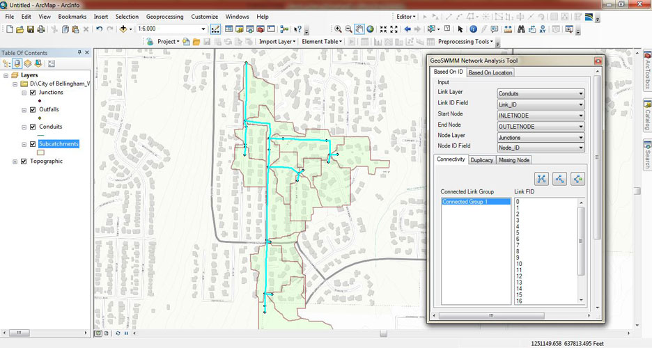
Network Analysis Tool
Analyze network connectivity problems and displays the result in ArcMap
Visually displays exactly where the issue exists
Finds the connected components and shows how they are disconnected
Shows where the links and nodes are missing
Finds where the network is physically connected, but logically disconnected due to wrong data entry
Shows where the same location have multiple nodes or links
Finds out the nodes and links that have the same ids
Finds out the unused nodes
Find links and nodes with invalid geometry
Conduit Roughness
- Assign conduit roughness values based on conduit material
- Optionally assign roughness based on the combination of conduit cross section type and material
Use SWMM reference table or external data file to assign suitable roughness


Width calculation
Determines characteristic width of sub-watersheds for hydrologic analysis.
Allows users to adjust effective channel length and overland flow path length during calculation, thereby makes better approximation of system characteristics.
Allows users to quickly find the head-watersheds, and their longest flow path lengths from a DEM.
Special length adjustment provisions are kept for head-watersheds. Users can adjust the parameter in a table.
Use two most reliable width calculation methods to determine the width.
Slope Calculation
- Find average surface slope of model sub-catchments using DEM dataset
Calculate slope as weighted average of the intersected raster cells


Land Use Property
- Comprehensive options to reclassify a reference land cover data (e.g. the USGS NLCD 2011 land cover data) to the simplified land use types for SWMM
- Assign suitable values for the Manning’s N and the depth of the maximum depression storage for each land use type from reference table
- Load previous reclassification or save reclassification for later use
- Calculate N- and D- values for sub-catchments as weighted average of intersected land cover
Watershed Delineation Tool
- Delineates subwatershed boundaries for hydrologic analysis and simulation
Allows automatic adjustment of raw DEM data for smooth processing of subwatershed delineation
DEM raster clipping option to accurately specify the study area and accelerate delineation process
Advanced stream-burning option allows to account for existing channel layout during delineation process
Create and manage stream layer for the delineated subwatersheds
Specify and manage outlet locations at stream confluences, using existing layer or by manual digitization


Imperviousness
- Find the area-weighted average surface imperviousness of subcatchments
Raster or polygon feature can use to find surface imperviousness
Model Creation From Existing GIS Data
- Efficiently design a complete model
- Drag-drop GIS Layer data into model
Extracts model information directly from the external GIS data source and assigns them perfectly to the model components.


Automatic calculation of geometrical properties of model elements
- Populate sub-catchment area and conduit length automatically from gis.
- Use user defined area or length for model adjustments.
Run the model using automatically calculated values or user defined values according to modeler’s preference.
Input File to Model And Export Model to .inp File
- EPASWMM standard .inp file export
- Build model from existing .inp file
- Data validation with projection system checking during model creation

Input File to Model And Export Model to .inp File
- EPASWMM standard .inp file export
- Build model from existing .inp file
- Data validation with projection system checking during model creation


Tabular view of model data
- View all the model elements of one category in table
- Easily update model data using the tabular view
- Both simple and composite data for each element can be updated from tabular view.
Control Rules Editor
- Avoid error in defining control rules using self guided rule editor
Create control rules simply by clicking and entering some values in suitable fields
Validate control rules even before leaving the editor


View Profile Plot
- View all available paths between a start node and end node.
- Generate water surface elevation profiles along with the links for desired path.
- Run simulation of the surface elevation based on predefined time length.
- Simulation can be paused, forwarded and rewound.
View Time Series Comparison
- Time Series Comparison illustrating the comparison between a pair of variables, e.g. flow rate in a pipe vs. water depth at a node with respect to time.
- Fast and accurate system modeling, analysis and design for visual comparison of input time series and results.


View Time Series Comparison
- Time Series Comparison illustrating the comparison between a pair of variables, e.g. flow rate in a pipe vs. water depth at a node with respect to time.
- Fast and accurate system modeling, analysis and design for visual comparison of input time series and results.
View Output Result in Table Format
- Enables to list and view time series output results of a single object in a table.
- Table data exportable to .csv format


